
Mt Logan- The Fickle Mountain
- Sean William Mackey
- Oct 25, 2025
- 12 min read

I have been to Canada numerous times, but I have been limited to the easy access, honey pot areas like The Rockies mainly around Canmore and Banff. When I was offered the opportunity to lead a rope team on an ascent of Mount Logan I jumped at the chance, but didn’t really know what I had signed myself up for or indeed where the mountain even was.
Mount Logan (5959m) lies on the Canadian-Alaskan border in the remote Yukon Territory. It’s the highest mountain in Canada and the second highest on the continent of North America. As such it attracts those who are trying to complete the highest mountain in Canada and also the very specific group of esoteric list tickers the less well known ‘Second Seven’ collectors. Most people know of the seven summits challenge, which entails climbing the highest mountain on each continent. However, these have become honey pots and commercial lessening the overall experience of an expedition. The new in vogue challenge for those with more money than sense is to climb the second highest on each continent and dodging the crowds. It also drastic reduces the costs…
Mt Logan was first climbed in 1925 by a Canadian-American-British team and this year marks the Centenary of the historic first ascent. As such the Canadian Park Rangers normally only see 20 or so teams attempting the various routes each year. This season that has almost doubled with the most ever seen. Over 34 groups (120 people) have had permits granted so far; making this year the busiest on record. Of the 34 or so groups the majority are attempting the ‘easiest’ route known as the King Trench, which was also the route of the first ascent team. Indeed in 2026 a team are attempting the route in what they consider a pure fashion- period 1920’s clothing, equipment and nutritional plan!
The group I was working with were all Brits and from a real mix of backgrounds. With each rope team leader taking two mountaineers we ended up with four rope teams of three that were able to move independently. Looking at the teams on Mt Logan it’s the smaller groups that seem to have the most success.

The Park Ranger station in Haines Junction is the starting place for all expeditions with the mandatory briefing for all of us on the nuances of this remote region. My romantic expectations of a small log cabin with radio equipment and maps couldn’t have been further from the truth. The government funded rangers and search and rescue (SAR) are housed in a vast purpose built building with large windows over looking the mountain scenery. The high tech structure housed over 30 staff in the summer that over see the vast 22,000 square kilometres. The opening statement from this friendly crowd of Rangers and SAR personnel is that going to Mt Logan is like going to the moon. Its desolate and frigid glaciers are featureless and unforgiving.
Support and rescue are often difficult and prolonged in nature. The most serious injuries can be helicoptered off the mountain side in anywhere from a 2hr to 36hr window depending on the cloud cover at the time. Although people have been known to wait many days for extraction until the mountain grants them a weather window to fly. The SAR helicopter is based from the hospital in White Horse which is a two hour flight from the mountain. With it being further away and in a low plain it often has a separate weather system from Logan itself. With good weather on the mountain side they sometimes cant take off due to poor weather in White Horse.
Only two companies regularly guide on Logan and are experienced with the area. It’s not normal for the guided parties to have doctors or medics on their staff. The guides working the routes normally only have a 2day first aid course! With this level of complexity having a communication strategy that works is key. We carried two sat phones between us and almost everyone had a Garmin Inreach. There is no mobile phone service anywhere in the region! We did take a small deployable starlink (Star Shield) while gave speedy internet access and made getting weather updates quicker and more accurate. Keeping all these electronics charged is hard to do, but decent quality 25kwh solar panels were able to gather enough light to even trickle charge from inside a tent during a storm. Pretty impressive.
The travel to Canada was pretty painless with flights from London to Vancouver and then an internal flight to the old prospector town of White Horse. Our Air Canada flight checked our baggage all the way through, and we were thankfully reunited with them on the carousel at White Horse. The 8hour time difference caused brutal jet lag, but the journey couldn’t have been much easier. Ice Fields Discovery (the small access airhead) was another 3hour bus journey north to reach from White Horse. This bus service has to be booked in advance and saves the costs of hire cars or taxis considerably.

Ice Fields Discovery is the only outfit who fly climbers and drop them onto the Logan Glacier to start the routes. The skid planes are small and exciting to ride. Seating four individuals with kit and equipment they will often make several trips for a drop off at base camp. Careful planning must be considered for larger groups. When we were there one large team initially flew out four paying clients in their first lift only to not get another lift in until the following day. These clients didn’t have the essential group kit like stoves or fuel to melt water or cook with and had to beg steal and borrow until a flight could be organised. Planning is everything with this sort of expedition.
During the summer months much of Ice Fields Discovery’s time is taken up with tourist flights and trips to their glacier ‘camp’ where people can spend a couple of days in the heated comfort of a storm proof cabin on the glacier, allowing them to get the real Yukon experience. These tourist flights take precedence over all other flights as they’re so lucrative. If you finish the mountain early you will just sit at base camp and wait until any scheduled or booked tourist flights are complete before getting picked up. We waited 8 days at base camp due to weather and tourist flights before we got out and back civilisation.
Their base at Silver City has a comfortable bunkhouse and some other amenities, but is a 2hour journey to the nearest supermarket. The logistics of food and fuel was planned well ahead of us leaving, but if you felt like winging it and just picking up some stuff on the way north you would be unlucky and pretty hungry. We preordered specific lightweight mountain food from Peak ReFuel, which is an USA company. Their freeze dried meals were excellent, varied and pretty tasty. My particular favourite was their beef stroganoff which packs in an impressive 1050Kcal for 200g of dehydrated weight. For lunches we used Real.Meal bars which were perfect with the right amount of calories to weight. With some careful packing we managed to get the rations for each day to just below a kilogram.

Mount Logan is a pretty complex piece of terrain and the mapping is limited. The mountain is a long plateau over 10km long and 2km wide with numerous ridges and glaciers running off the summit. The main rock type is granite but it is quite fragile and loose in places. Having a friend who works in the British Army geo team was leaned on heavily and he produced 1:25k mapping of mountain for us. Stanford Maps have a 1:100k but missed much of the detail. Being so far north did mean that any compass bearing meant adding 18 degrees to the direction of travel to translate it from the map to the ground accurately. With the white outs we experienced having prior experience navigating in poor Scottish conditions paid off and we spent some of the time walking on a bearing.

The routes;
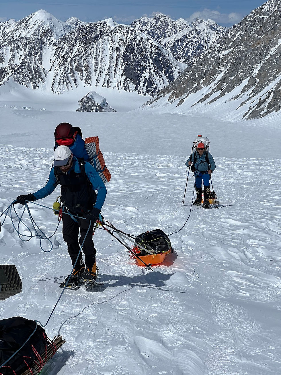
The most common routes to the summit is via the King Trench. This long glacier tackles the west side of the massif and snakes between Queen Peak and King Peak. It then takes a steeper path to the enormous summit plateau. This is the route of the first ascent and is probably graded alpine Fascile. While the technicality of the route is low the physicality is high. Long approaches while carrying 20kg packs and pulling 30kg pulks isn’t easy even for the most fit individuals.
The East Ridge is another common route but is a more difficult challenge. With the entire route graded Difficile with pitches of Scottish III/IV. It has numerous successful ascents each year with the climbing teams then crossing the mountain and descending via the King Trench route. Even more careful packing is required as pulks can only be used to get to the base of the route from the skid plane landing site. Big load carrying days is required to live and move up the ridge.
Hummingbird Ridge is probably the most notorious route in the Yukon and has only seen one ascent. Being relatively close to the coast the weather systems can often push small birds off their littoral flight path and they meet their demise on the harsh ice slopes of the mountain. A poor Hummingbird landed on the Ridge during the first ascent which gave it the name. Groups have cautiously tried to make the coveted second ascent but none have been successful. Indeed, the body of one the hopeful alpinists can still be seen hanging from their ropes on the route…
My teams objective was an ascent via the King Trench route. The skid plane dropped us off at the base camp in three loads of people, equipment, food and fuel. Being independent and having a heavy contingency of food and equipment made my preferred method of alpine fast and light impossible. We were thankful of the food and planning at the back end of the trip though.
Three other teams were at the base camp waiting to be collected when we arrived having either summited or turned back. At the time of writing only three groups had successfully reached the summit of the mountain in 2025. The usual weather system for the time of year was for an area of high pressure to sit over the Klune Ice Fields and to have nice stable weather for the majority of the season. Not so in 2025. The summer weather is normally -4’C to -15’C but this year we experienced wind chill as low as -40’C which tested us and our kit to the limit. Before we even stepped onto the plane we had waited four days due to bad weather before there was a suitable weather window to fly in.

Arriving in base camp at 2750m we spent a night acclimatising before beginning the move up to camp one (3250m). Pulling the pulk sleds fully laden was hard graft but did take much of the load off the shoulders and was certainly more efficient than conducting multiple load carries up the mountain. The preferred method of pulling the sled compared to the arctic crossing method is a little different in North America as the ground only allows for the sled to be pulled for the first couple of camps but not higher. All the climbers rig their own system from their rucksack hip belt to a central strong point trailing behind them to attach the pulk too. The pulk can then be ditched when it’s no longer tenable to drag it and you can carry on with just a rucksack. In comparison, most polar explorers put all their kit and equipment weight in the pulk and drag it from a specially designed body harness. This could also work but apparently it isn’t commonly used on Denali or other arctic mountains at the moment.
During the arduous move up to Camp one the weather began to deteriorate and visibility dropped to less than 10m with my good friend Phil Coleby leading his rope team ahead of mine struggling to see much in the difficult flat light. We decided to make camp after seven hours of dragging and schlepping up hill as we couldn’t see crevasses anymore or indeed where camp 1 was supposed to be. Checking the weather on Garmin we found that a huge storm had developed and we were about to be hit with 80kph winds and heavy snow for 3 days. It certainly changed quickly.

Digging in a flat platform and building high walls to protect our tents from the elements took a few hours but we were in and set before the storm hit us. Over the next four days I must have shovelled tonnes of snow and ice off our tents and built the walls higher than I ever imagined necessary. When we emerged from the storm at least 2m of snow had fallen and rather than a walled camp we were deep in a pit we named the bomb crater. My tent took a battering and had ripped in several places. The running repairs we had done at the time had to be properly mended with some nifty needlework and plenty of Gaffa tape before we moved on.
With visibility back to normal we were actually only a couple of hundred metres short of camp 1 which had been completely buried in the storm. We continued the journey up to Camp 2 and increasingly steeper ground. This is where my inexperience with pulks surprised me. The constant need to hold the weight to prevent it slipping down hill was energy sapping and forced us to develop some techniques to allow for decent breaks to be taken. The easiest route forward dodging the worst of the hazards had been helpful marked with flagged canes earlier in the season. Some were visible and some were buried or blown away. We had brought our own and replaced them where we could.
Camp 2 sits at the top of a broad Col directly between King Peak and Queen Peak. The route upwards to Camp 3 follows a twisting and turning marked path to avoid some massive seracs and crevasses. This short weather window was not to last and another storm rolled in. While not as fierce as the last one it did prevent further movement upwards. It was while we were making a plan over a coffee in a tent that one of team came to us with a swollen and blistered finger. Our experienced and robust expedition doctor Josh Mackey (no relation!) quickly diagnosed frostbite and that he needed to be extracted. Earlier Josh had also tended to a damaged ankle which prevented another team member coming up the mountain with us.
Faced with a deteriorating weather forecast, time slip[ping away and team members suffering injuries we made the hard decision to descend. Making decisions like this are always difficult and leave you second guessing yourself. Could we have gone further or higher if we had just pushed it a little more? Fundamentally, I don’t believe any choice in a high pressure situation is 100% perfect, but an 80% solution in a timely manner is often the best choice. You win some and you lose some. I just didn’t want anyone to lose fingers.
The route down was easy in comparison to the way up, but with the mountain echoing with our expletives. For those that haven’t dragged a pulk down hill before the rage you will develop for this piece of plastic can only be experienced. It will neither do what you want or indeed what you expect gravity to do to it at any point.
Reaching base camp before the good weather left us, we then spent a further 8 days waiting for the skid plane to make it through the weather and to pluck us from glacier. Once back at the airhead the difficulty we experienced became more apparent with teams all over the mountain finding it equally as challenging. Most reached the summit plateau at Prospectors Col but none seemed to make it further.
Reflecting on the trip I’m ultimately disappointed not to have summited and stood upon one of the least known and remotest mountains in the world. Losing two weeks of the trip to weather made the Exped lose momentum and in the end the only sensible choice we had was to save it for another time.
Essential kit
MSR GSK Multi fuel stove. This bomb proof stove has been a staple of remote expeditions for years. While gas canisters can be sourced and flown in the temperatures make them inefficient and sluggish. The MSR Super fuel is cheap and pretty clean burning meaning less messy maintenance. I used the standard fuel pump which caused no problems but an arctic fuel pump is also available for use below freezing.
Mountain Equipment Redline Long sleeping bag. Going to comfort -40’C this down filled bag out performed all others taken. Of the three of us who had one we were the warmest, slept the best and must therefore have been the best to recover. I’m 6’2” and need a long sleeping bag and this fitted the bill perfectly.
Garmin Inreach. This nifty gizmo allows two way messaging anywhere in the world. The weather service provides a five day forecast and then it is broken down into hourly segments. The SOS button on its side goes to a 24hour manned operations room which then informs local SAR teams. The battery lasts ages and it weighs less than 200g.
Julbo Sheild Cat 4 Sunglasses. I’m a big fan of Julbo and have goggles and sunglasses from them. With high UV and reflected light from the ice and snow a decent pair of glacier glasses are essential. I coupled these with a OuterU mid face mask which kept the worst of the sunburn off my nose and cheeks. Needless to say if you can grow a beard I would recommend relaxing your grooming regime to protect the rest of your face.


Comments